WEDNESDAY, 5 MAY 2021
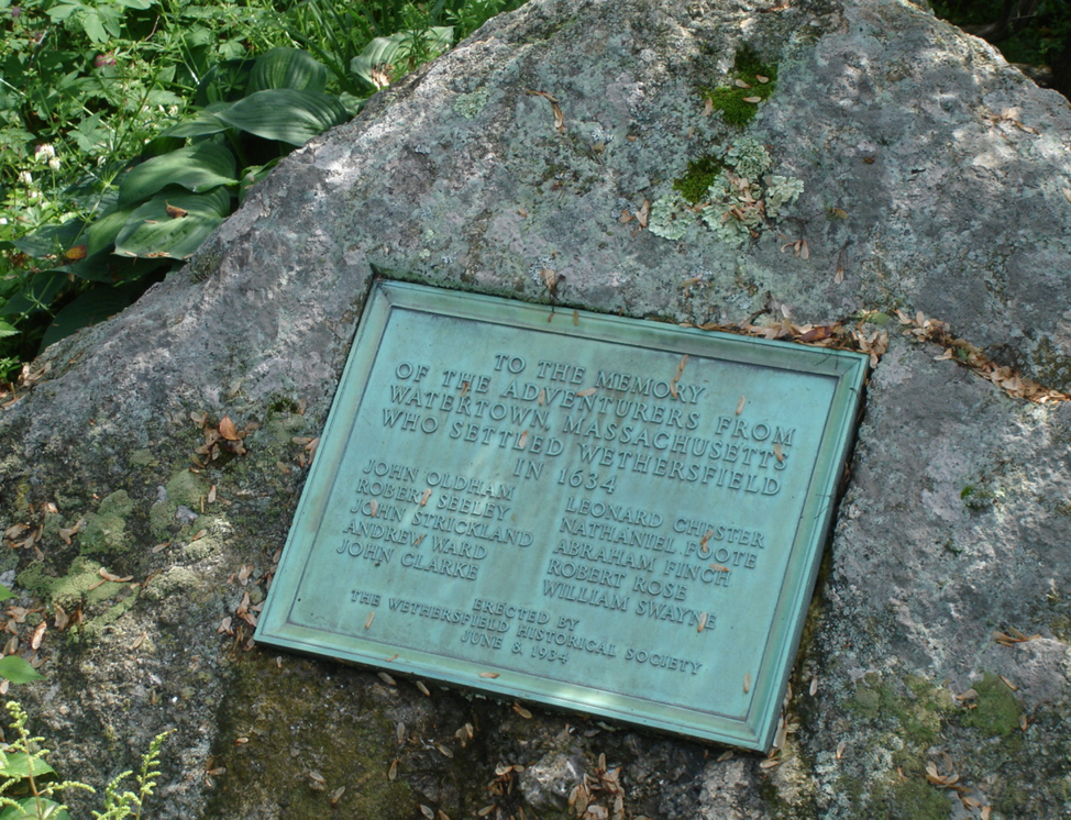
The Boating Genealogists trip to Wethersfield Connecticut was a pilgrimage of sorts. I wrote in my book Discover Your Roots! How I found My North American and Revolutionary War Ancestors that I traced my Wright family ancestry back to Thomas Wright, one of the first settlers of Wethersfield, and several of the Ten Adventurers, Robert Seeley, Nathaniel Foote, Robert Rose, William Swayne, and possibly John Clarke, that came first to Wethersfield. Both of our families have several Wethersfield lines.
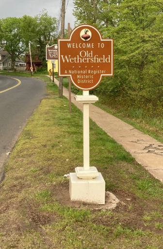
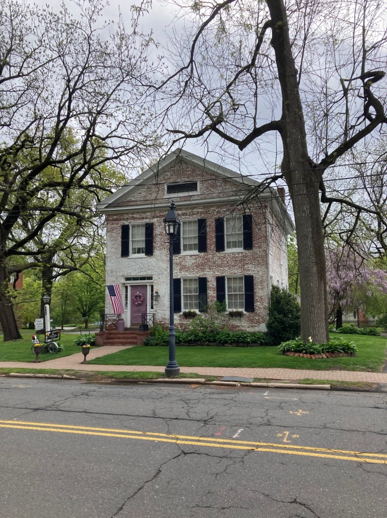
Visiting Wethersfield and other nearby locations was fantastic even in the current Covid pandemic. Arriving Wednesday afternoon we located our base for the next five days in Old Wethersfield. We stayed at the Chester Bulkley house located next to the Historical Society building and a block from the old cemetery. Our host was gracious and the charming, cozy, accommodations met our expectations for an early 1830s house. The breakfasts were excellent and our host steered us to great local dinner establishments.
On arrival in the afternoon we wasted no time and began a search of the cemetery for ancestral markers. The cemetery is well documented and between the cemetery guidebook furnished by our host and the online interactive map we were able to locate numerous ancestral burials.
THURSDAY
The next day we visited the Wethersfield Ancient Burying Ground again. We noted that one of Thomas Wrights sons, Joseph Wright, had his grave marker listed on the Findagrave website but the photo of his grave had only a wooden post. Fortunately we were able to locate his marker, take a photo of it, and add a small piece information to the family history. His stone is uphill and to the left of the large Boreman monument, a family that I descend from also. It is in the same row (about five spaces away) from his own son Deacon Thomas Wright.
Since Wethersfield was going to have a bike touring festival over the weekend, we were interested in renting bikes. Wethersfield had no rental facility so we looked elsewhere. We attempted to rent bicycles in Middleton CT but were informed by the store personnel that all of their rental stock, indeed all rental stock for all of the bike stores in that part of the Connecticut area, had been sold off due to a dearth of new bike shipments because of the pandemic. Even some new bike orders were not to be filled until 2023.
Undeterred in our fervor for our genealogical expedition we next visited Colchester CT. As we were to experience throughout our trip, few historical societies or museums were open due to the pandemic. We did not have access to the exhibits and research materials that we had hoped for. We had better luck with libraries. We were able to access the Colchester library and do some research in their genealogy room, but we did not find much new information. Deciding to leave the realm of sparse paper documentation we parked in front of the Colchester fire station and visited the Colchester Burying Ground behind the station.
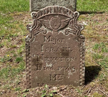
The Colchester cemetery did not have a map posted so we wandered the grounds. The cemetery is mowed but it is not in good condition. After a search we located the graves of Major Israel Newton and his wife Hannah Butler Newton. A soldier in King Georges War, he died at the siege of the French Fort Louisburg at Cape Breton Island in Nova Scotia, taking in battle from the French what was at the time the largest fort in North America. Although he may be buried at that place, we were chagrined that his grave marker at Colchester was not marked with a Colonial War marker or a flag, as were several other nearby graves. We made a note to bring that fact to the attention of the town and to the attention of the Connecticut chapter of the General Society of Colonial Wars in America.

We left Colchester and made our way to Hadley MA, the resting place of the families of my 10th great-grandfathers, Nathaniel Dickenson and Lt. Samuel Smith, and my 9th great-grandfather Richard Montague. As I mention in my third book, Discover Your Roots! Rediscovering the Heroes of the Indian Wars of New England and New Netherlands 1636 – 1698, Lt. Samuel Smith was a soldier in the Pequot war and Nathaniel Dickenson was the father of John Dickenson, my 9th great grandfather. John Dickenson was killed at the battle of Turners Falls, and his father Nathaniel also fought there. Nathaniel was an early settler of Wethersfield who moved to Hadley MA from Wethersfield and it was at Old Hadley Cemetery, established in 1660, that we located his family plot.

Marked now by a large granite boulder and an attached plaque, his original ancient marker, like so many other markers that we attempted to locate, is now seemingly impossible to find due to unreadability, subsidence or loss. We also located a marker dedicated to my ancestors Richard Montague and his wife Abigail, also early founders of Hatfield and Hadley.
About 20 miles from Hatfield is the site of the Battle of Turners Falls. The battle is considered the turning point of King Philips War, a war where more English colonists were killed per capita than people killed per capita in the American Civil War. We looked for the monument to Captain Turner the leader of the Colonists and also looked for the site of the battle, but neither place was well described in Internet sources. Both the Turner monument and the location of the battle were difficult to find.
Turner Falls battle site is sometimes misleadingly described on the Internet as having taken place at Turners Falls in Gill MA. We stopped in at the one room library of Gill and the librarian kindly directed us to the location of the Turners Falls monument, noting that “the monument might not pass today’s edits”. To describe Gill as a small hamlet is to exaggerate its size. The battle actually occurred four miles from the hamlet of Gill at the border of the present day city of Turners Falls.
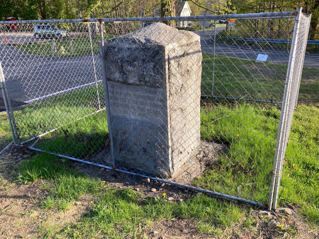
At the intersection of Hwy 2 (aka Avenue A) and Main Rd. (aka Mohawk Hwy/French Kings Hwy), just north of the city of Turners Falls, on the river, across from a gas station, and currently behind a small chain link fence stands the memorial monument to one of the most important battles of King Philips War, the battle of Turners Falls. This small monument is all that marks the location of the battle.
Captain Turner was the colonial leader of the expedition into the hornet’s nest of King Philip’s army. He was killed after the fight a short distance from the battle while crossing a creek. His monument and roadside marker are at the Greenville MA Green River Park at 31 Nash Mill Rd., outside of the black bar fence that encloses the park, near the western edge of the park parking lot.

The Battle of Turners Falls took place in 1676. It is striking that a battle of such moment and significance is almost forgotten, along with the war in which it was fought, a war for the very existence of the colonists the descendants of whom 100 years later were to declare their independence from Britain. It is striking also that we Americans today are so severed from our colonial history that remembrance of the battle and of its significance to the survival of the early colonies is almost nonexistent.
FRIDAY
Friday we visited Wethersfield’s Ancient Burying Ground again to locate the grave of my 7th great-grandfather Moses Crafts. According to The Crafts Family by James M. and William F. Crafts, Moses was a settler in several towns, including Deerfield MA where he and his wife operated an inn and tavern prior to King Philips War. After the town was attacked Moses and his family moved to Hatfield MA.
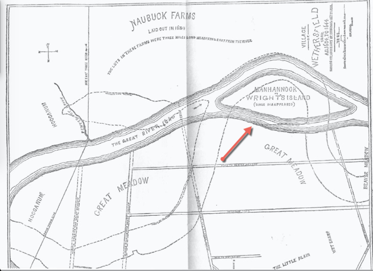
Our second stop was the current location of what was once called Wright’s Island. A settler of Wethersfield CT by 1640, Thomas Wright and his family were the first Wrights in my family line to live at Wethersfield. The Wright family once owned the Wethersfield area island that was called by the Indians Manhannook and took the name Wright’s Island. In volume 2 of his book Ancient Wethersfield Henry Stiles describes the island as 1.5 miles long and containing about 200 acres.

Wright Island (Bend 3) from dissertation study by Jamie Grant, U. Conn., 2015
The area is no longer an island. Due to the Connecticut River changing course over time the island is now a gentle curve of land adjacent to the river. We walked for a ways and saw other walkers enjoying the pristine area. The flatland area is now used to farm and as a game club/shooting range.

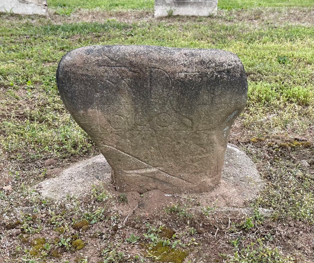
Wallingford CT was our next destination, 21 miles from Wethersfield. The Wallingford Historic Society was closed so we visited the cemetery. The cemetery had a large map at the entrance and several of the oldest graves are marked with easy to see posts. Using the map, we located the markers for my ancestor Nathaniel Merriman who was a soldier in the Pequot War, our ancestor Abraham Doolittle and many others. Abraham Doolittle’s marker was striking, a small asymmetrical boulder inscribed with the year of his death in 1690. Accompanying that marker was a large granite monument dedicated to him by his descendants. The Wallingford cemetery was in good condition and well cared for.
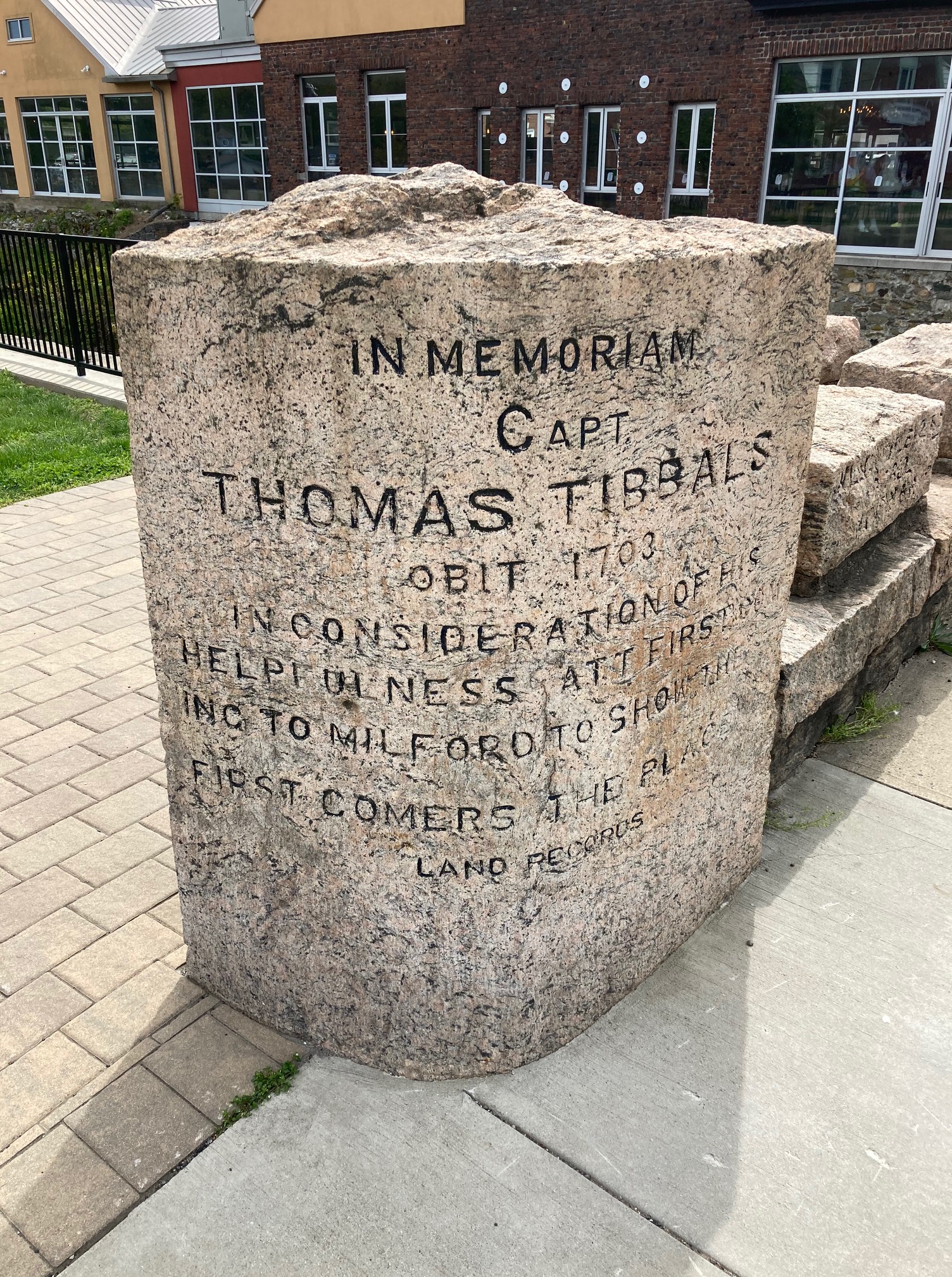
We then made the 23-mile drive to Milford CT. We parked at the Milford library and did some research at the library. We found two maps of the old town of Milford in books there. Next to the library is a bridge and on the bridge are numerous large stones with the names of several of my ancestors including Thomas Tibbals, George Hubbard, Richard Baldwin, Elizabeth Alsop, Sarah Baldwin and Joseph Northrup. Thomas Tibbals who initially led the founding group of settlers to the site that would become Milford has a large cornerstone on the bridge and William Fowlers ancient millstone is incorporated into the structure.

We visited the old Milford cemetery next. The cemetery is not in as good condition as Wallingford’s but was generally well kept. Nonetheless, along the side next to the railroad track, the cemetery is in danger of becoming overgrown. Many of the stones in the ancient cemetery are leaning. With the help of the cemetery map posted by the large Revolutionary War Memorial obelisk at the back of the cemetery we were able to locate the marker for Joseph Northrup. It is the marker nearest to the large memorial slab dedicated to the Northrup family by their descendants.
SATURDAY
The Wethersfield Historical Museum was finally open on Saturday after being closed earlier in the week. The museum had some nice pieces and exhibits describing the town history. The curator was very knowledgeable and directed us to the nearby site of the Swain homestead where two of the daughters of my 11th great-grandfather William Swain (Swayne) were kidnapped in the bloody Pequot attack on Wethersfield in 1637, the attack that lit off the Pequot War. The young women were subsequently ransomed from the Pequot by the Dutch in a harrowing exchange through the release of seven Pequot captives. That story is documented in John Underhill’s book, Newes from America, on page 24.
After our visit to the Wethersfield Museum we visited the Ancient Burying Ground at Hartford CT, a place where the famous Rev. Thomas Hooker is buried. At the center of the cemetery there is a large obelisk inscribed with the names of the first settlers of Hartford including our ancestor Richard Butler, and many more of our ancestors.

There was no map of the site so finding specific markers was difficult. We did locate a memorial plaque and an associated memorial tree planted in recognition to Richard Olmstead and his family as early settlers of Hartford.

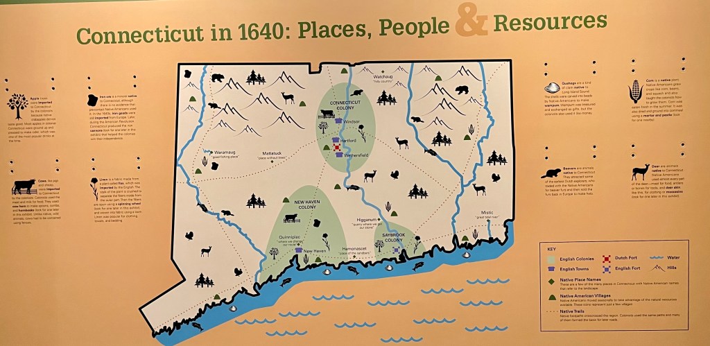
After leaving the Old Burying Ground of Hartford we visited the Connecticut Historical Society Museum and Library, also in Hartford. Its exhibits were open, but the research archives were closed. We were informed that due to the pandemic those archives were only open by appointment, and that appointments need to be arranged two weeks ahead of time. The picture below is from one of their exhibits.
Connecticut Colonies in 1640 – New Haven, Connecticut, and Saybrook in green(L-R)
SUNDAY
The next day we again made the 66-mile drive from Wethersfield CT to the Deerfield MA area. Deerfield was once on the far western frontier of colonial MA, which made it a target for French and Indian attacks numerous times over the years. My ancestor Richard Weller was a first settler of the town. In September 1675, during King Philips War, Indians attacked the town after killing a large portion of its male population at what has since been called Bloody Brook, including a son of Richard Weller’s. Deerfield was then abandoned. The town was resettled after the war ended. Richard Weller returned to Deerfield at least by the 1680’s and probably died there in 1690.
The Deerfield Memorial Hall Museum was open. Its holdings are extensive and the staff was well informed and very helpful, even providing a map of the Old Burying Ground. The exhibits included plaques to those resident at the time of the attack in 1704, and to those who died attempting the rescue of the captives after the attack including my ancestor Samuel Boltwood and his son Robert. Near those plaques was the exhibit of the garrison house door that was hacked through by the French and Indians creating a hole through which a settler woman was shot and killed by the attackers during the attack.
The French and Indians attacked Deerfield in 1704 at the start of Queen Ann’s War. That attack was catastrophic for the town. The Old Burying Ground of the town has a mass grave where 48 men women and children killed in the attack are buried. Some of the people killed were ancestors of mine. Samson Frary was killed during the attack along with members of his family except his wife. My ancestor Samuel Boltwood and his son Robert were ambushed in Deerfield’s meadow as they pursued the captors. Along the way to Canada Mary Frary, Samson’s wife was killed. She was one of 109 people captured and marched toward Canada that day. Many of the graves in the cemetery are unmarked.

Deerfield has many houses dating to the early 1700’s. None of the houses were open to visitors due to pandemic closures but a walk along the mile long street gave us an ample introduction to the ancient town and a feeling of going back in time to those early days. Many of the houses are posted with the name of their owner in the 1700’s and we saw two ancient wells, one well dating to 1690.
MONDAY
This day marked a return to our own home and a full return to the 21st century. Although we did not get the opportunity to research records as much as we would have liked to, the trip was a success. On the way home we fully immersed back into the pandemic. Recalling the challenges our colonial ancestors surmounted in the 1600’s and 1700’s the current pandemic and terrorism pale in comparison.
© 2021 by Bruce Wright
