The Boating Genealogists stepped back in history again to the colonies of Rhode Island and Massachusetts and to Wind Gap in early colonial Pennsylvania’s Pocono Mountains.
First Stop – Site of Dietz Blockhouse – Wind Gap Pennsylvania
9/12 Friday– The first place on our itinerary was Wind Gap Pennsylvania, once called Dietz Gap. The town of Wind Gap is situated on the Appalachian Trail at a gap in the Pocono Mountains. In the mid 1750’s during the French and Indian War it was a strategic location for the defense of the surrounding area. A string of forts was built for the protection of the many German immigrants and others that were moving into the area. One of the forts, called variously a house, a fort and a blockhouse, was built by Johan Adam Dietz. The name Dietz is spelled in many ways and appears in records as Teeds, Teel, Deitz, Deets etc.
In preparation for the visit we went to the Sigal Historic Society in Easton Massachusetts and met with Howard, one of the library’s researchers. We previously contacted the library and thankfully Howard had already pulled a half dozen highly relevant references to the former site of the Dietz Blockhouse. We spent several hours reading and copying the references and left with a much greater knowledge of Wind Gap and the Dietz fort location.
As we read through the books and records, we saw Johan Adam Dietz was also called Adam Dietz. Looking into the naming discrepancy we noted that many of the men named in the records were named Johan. Looking a little deeper we learned that it was customary for Germans in the 1700’s to name a boy Johan at his baptism and call him by his second given name. [2]
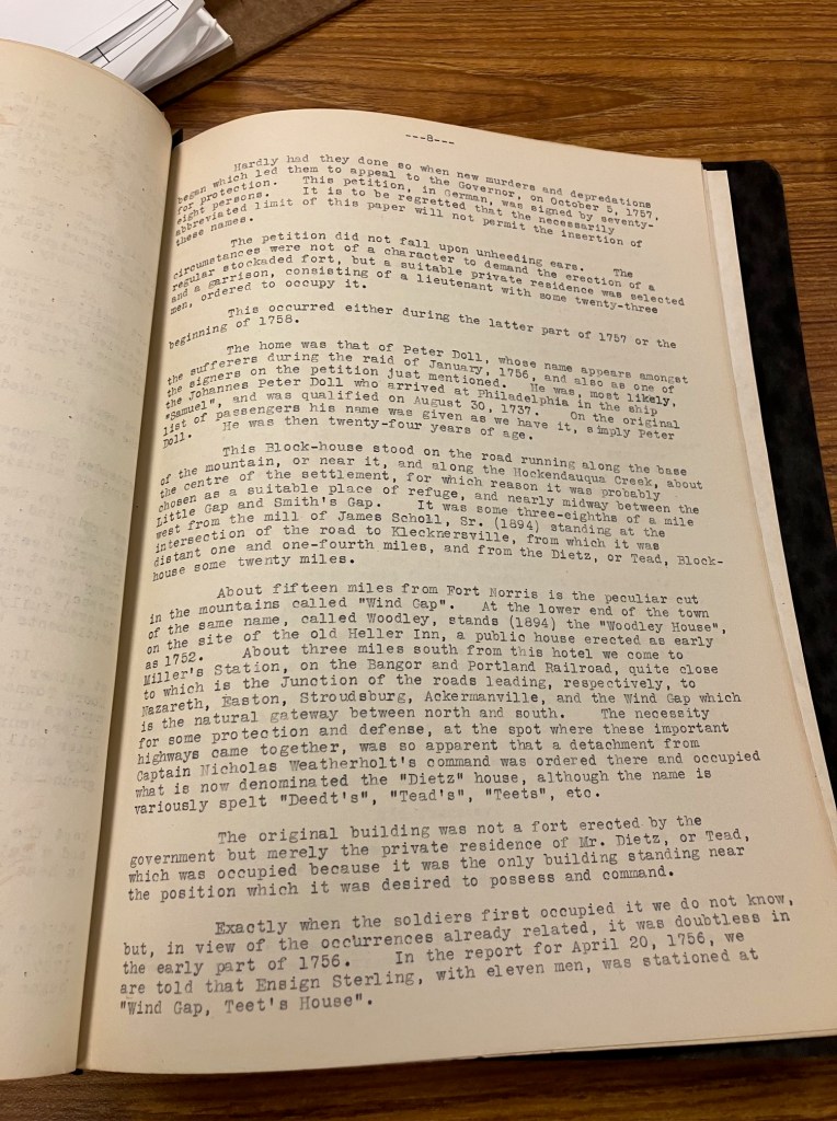
Saturday – 9/13 – After reading the early 1900 accounts we began our search for the location of Dietz’ Blockhouse. An account by a historian, calling the place Teed’s Blockhouse, (one of many Dietz misspellings), placed the location close to Grand Central Road & Delabole Road, in Plainfield Township. In some accounts the site is described as muddy with “bad water”. It’s location is given as about 75 foot downhill from Doll’s blockhouse, and in the early 1900’s its location was placed near Millers Station and close to a railroad:
” The original building was not a fort erected by the Government, but merely a blockhouse, the private residence of Mr. Teed, which was occupied because it was then the only building standing near the position which it was desired to possess. This position was certainly an important one, commanding as it did the roads to and from the Wind Gap, the Forts at and near the present Stroudsburg, Easton and Nazareth From the Wind Gap, proper, it was distant four miles in a direction south slightly east, and from Woodley, the lower end of Wind Gap, some three miles. Its distance from Nazareth was six miles, and from Easton about twelve miles. The Fort, or Blockhouse, stood near the present Miller’s Station on the Bangor and Portland RR, about 350 yards east of the station building…” [3] [4]
Using the location description given in the records we looked for the site of the fort. We looked at the area of the intersection at Grand Central Road & Delabole Road near Wind Gap but it was not swampy and there was no railroad. Thinking that maybe Millers Station was a town or a railroad station we looked for a town or a railroad station of that name but there was none to be found.
The railroad seemed to be the last key to locating the fort. Following Delabole road we noted a bike trail cutting the road. Thinking maybe this could have once been a railroad and now was converted to a bike path we searched for the bike path’s history.

The name of the railroad in one account of the fort’s location was Bangor and Portland. Looking up the history of the Plainfield bike trail we saw that it was built over the Bangor and Portland track. We looked for a map of the railroad and found it. Miller Station was noted on the map, approximately at the Plainfield trail intersection with Delabole road.

Putting an image overlay of the Bangor and Portland railroad map showing Millers Station over a Google Earth Map’s pinpoint of Plainfield Township Trail at Delabole road, the location approximately matches the historian’s description.
Thinking we had located the general site of the Dietz blockhouse we walked the Plainfield trail from a trail head to Delabole road and from that intersection about a 400 yards east up the road. The location on the north side of the road was muddy and swamp-like and on the opposite side of the road the land sloped up. Like Millers station, both the railroad and Dietz’s blockhouse are gone now but using the historian’s description we had located the blockhouse location. Everything fit.

The Dietz blockhouse was described as a useful fort and meeting place for troops during the hostilities of 1756-1758.[7] An attack on settlers near a fort, possibly Dietz’ blockhouse, is described as having taken place in June 15, 1758:
” this morning we heared the Disagreeable news of a Fort being taken at the upper end of the minisinks by a party of Indians supposed to be 40 in number the whitemen it’s said belonging to that Garrison were Farmers and were out in their planta- tions when the Indians fired on them and killed them where- upon the Indians marched up to the Fort and took all the weomen and Children Captive and Carryed them away …” [8] [9]
Possibly Johan Adam Dietz was killed during this French and Indian War. By one account, a letter written in December 8th 1763, his fort is called “late Dietz’s” and is being used once again in the war:
“But last Tuesday Col Clayton being here he was pleased to give me to understand that he had received your Honour’s Commands to appoint my station at Heller’s, late Teets’s, Gap to range from thence under the Mountains as far as the Water Gap of Delaware.” [10] [11]
He is also mentioned as an elder in his church in 1763.[12] He disappears from the record after 1763.
The blockhouse area today is covered with farmhouses and farmland, situated 9/10 of a mile from St. Peters Church on the edge of the town. There is no hint of the raids and destruction of 265 years ago. Cars zoomed by us as we walked around the area, no doubt oblivious to the area’s history.
We next visited the cemetery of what used to be called Plainfield Church and is now named St. Peters Church. Johan Adam Dietz was a founder of the church and with Casper Doll donated 25 acres of land where the church was built. The church has a large cemetery across from it. Many of the headstones are ancient and have distinctly German names engraved on them. There, we located the grave of Johan Adam Dietz’s wife Anna Dietz. She was the first person buried there. Johan Adam Dietz was not buried near her.
9/14 Sunday – We returned to the Deitz Fort location and rode on the nearby bike path for a scenic 11 mile ride. It is a beautiful hilly area. As we rode on the old railroad trackway I contemplated the carnage of the area’s past, now swept clean by the passage of time, blanketed over with nature’s autumn colors. Had we not investigated our family history we would likely never have known anything about the area’s amazing past.
[1] Henry M.M. Richards, The Frontier Forts of Northampton County, p. 8, Sigal Historic Society, 1922.
[2] Diane Haddad, German Naming Traditions Genealogists Should Know, Family Tree Magazine online, https://familytreemagazine.com/heritage/german/german-naming-traditions/#:~:text=So%20in%20a%20family%20with,continue%20to%20be%20so%20identified.
[3] Dr. Henry M.M. Richards, The Frontier Forts of Northampton County, p. 8-10, Sigal Historic Society, 1922.
[4] Thomas L. Montgomery, Report of the Commission to Locate the Site of the Frontier Forts of Pennsylvania, 2nd ed., v.1, p. 237-238, p. 243-244, Ray, Harrisburg, 1916. https://archive.org/details/reportofcommiss01comm/page/237/mode/1up and https://archive.org/details/reportofcommiss01comm/page/244/mode/1up
[5] Dan West, Northampton Railroad Station Table, https://www.west2k.com/pastations/northampton.shtml
[6] Thomas L. Montgomery, Report of the Commission to Locate the Site of the Frontier Forts of Pennsylvania, 2nd ed., v.1, p.236-238, Ray, Harrisburg, 1916. https://archive.org/details/reportofcommiss01comm/page/237/mode/1up
[7] William Hunter, Forts on the Pennsylvania Frontier 1753-1758, p. 233, 273, 275-283, The Pennsylvania Historical and Museum Commission, Harrisburg, 1960. https://libsysdigi.library.illinois.edu/OCA/Books2012-06/fortsonpennsylva00hunt/fortsonpennsylva00hunt.pdf
[8] William Hunter, Forts on the Pennsylvania Frontier 1753-1758, p. 270 , The Pennsylvania Historical and Museum Commission, Harrisburg, 1960. https://babel.hathitrust.org/cgi/pt?id=uc1.b4871658&seq=286
[9] Samuel Hazard, Pennsylvania Archives, Series 1 V. 3, p. 424, Severns, Philadelphia, 1853. https://babel.hathitrust.org/cgi/pt?id=inu.30000117725808&seq=430
[10] Jon Sinatra, This Od Farmhouse Dripping With American History, Morning Call News, Hellertown PA, 2012. https://studylib.net/doc/9606261/attn–the-morning-call-news–hellertown–pa-this-old-farm?__cf_chl_rt_tk=DUwWZCuz_FSlOSUOq_90eWFluw9opH5IJcG4vri3eN8-1761235652-1.0.1.1-.mHFTzCdh5TKLdFYsWdt7Tq4kLGouVJcHP8yZRPv0H8
[11] Samuel Hazard, Pennsylvania Archives, Letter from Lewis Gordon to Gov. Penn, December 8, 1763, v.4, Stevens Phil., 1853. p. 143-144. https://www.google.com/books/edition/Pennsylvania_Archives/2FMOAAAAIAAJ?hl=en&gbpv=1&dq=lewis+gordon+%2B+Hellers,+late+Teet+s+Gap&pg=PA144&printsec=frontcover
[12] Genealogical and Biographical Annals of Northumberland County, Pennsylvania, p. 484, Floyd, Chicago, 1911. https://archive.org/details/genealogicalbiog00floy/page/484/mode/1up
Copyright 2025 Bruce Wright, Esq. ©

Very nice story! Adam is my 5th great-grandfather and I’m just beginning to dig into the Dietz’s history. LOTS of info out there, including great stories like yours. Thank you.
LikeLike